jacksonville
This map covers the regions of Jacksonville, Florida, USA. It aims to give you a basic idea of the nature and characteristics of each region.
Jacksonville is the most populous city in Florida and is the largest city by area in the contiguous United States as of 2020 with more than 500 neighborhoods.
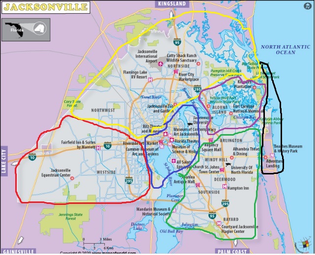
The blue area
The Downtown is Jacksonville’s central business district. The city’s oldest area, it is historically characterized by the city’s original boundaries set upon its creation. It is the nucleus of Jacksonville’s Urban Core, which includes LaVilla, Springfield, East Jacksonville, and Brooklyn’s surrounding communities, plus a portion on the south side of the St. Johns River known as Southbank.
The area that became downtown Jacksonville was on the north side of a St. Johns River crossing known to the Seminole as Wacca Pilatka and named after Andrew Jackson as the British Cow Ford called “Jacksonville”
For most of the American Civil War, the town was occupied by Union troops and steady development came after the end of the war, when it became one of the first major tourist designations in Florida. Jacksonville was annexed to several neighboring towns in 1887. Nearly all of downtown burned in the 1901 Great Fire, but soon afterward a major building boom followed.
Today Downtown Jacksonville’s concept of the city encompasses a broader area than typical Downtown Core and consists of many separate neighborhoods or districts.
The black area
The Jacksonville Beaches, locally known as “The Beaches,” are a group of towns and communities on the northern half of an unidentified barrier island identified to the east by the Atlantic Ocean, to the north by the St. Johns River, and to the west by the Intracoastal Waterway, called San Pablo Island, on the First Coast of the United States of Florida, all of which are exempt cities or parts of Jacksonville. The Intracoastal Waterway separates these areas from the main body of the city of Jacksonville. The Jacksonville Beaches are located in the counties of Duval and northern St. Johns County and are part of the metropolitan area of Jacksonville. General known as part of the Beaches, Atlantic Beach, Neptune Beach, Jacksonville Beach, and Ponte Vedra Beach is the major communities.
The yellow area
The Northside is a large area of Jacksonville, Florida, and is commonly understood as a counterpart to other large regions of the city, the Urban Center, Arlington, Southside, Westside, and the Beaches. The vast region comprises historic neighborhoods, cultural landmarks, protected habitats, and essential transport and logistics facilities, all of which are central to Jacksonville’s history and growth. Numerous communities are situated within the vast Northside city. These include the Black Hammock Island, Brentwood, Dinsmore, Fort George Island, Garden City, Highlands, Lake Forest, Longbranch, Moncrief Park, Norwood, Panama Park, Pecan Park, Oceanway, Ribault, Riverview, Royal Terrance, San Mateo, and Tallulah-North Shore, but are not limited.
The Northside was integrated into the city in 1968 as a part of the incorporation of Jacksonville, a city-county fusion between the City between Jacksonville and Duval County governments. The area houses a large portion of the city’s transport and logistics infrastructure, including Jacksonville International Airport, Jacksonville Station, JAXPORT Cruise Terminal, Blount Island Marine Terminal, and Dames Point Marine Terminal. The area also houses the Jacksonville Zoo and Gardens which relocated to the Northside in 1925 and has doubled in size since then. There is no clear description of what constitutes the Northside boundaries, but studies have shown that the vernacular area at 20th Street and west and north of the St. Johns River is considered to be approximately north of the Urban Center and Westside.
The purple area
Arlington is a wide area of Jacksonville, Florida with about 32 communities (Charter Point, University Park, Arlington Manor, Clifton, Oak Haven, Empire Point, Southbank, St. Nicholas, Spring Glen, Love Grove / Riviera Manor, Woodmere, Gilmore, Arlington Hills, Fairways Forest, Arlingwood, Arlington, Alderman Park, Woodland Acres, Gynlea / Grove Park, Hogan, Holiday Hill, Southside Estates, Beach Park, Hidden Hills, Fort Caroline Shores, Mayport, North Beach, Atlantic Highlands, Holiday Harbors). It borders the southern end of the Southside city and has many bridge connections to nearby beaches, the Northside, and downtown. The vast area was absorbed into the city in 1968 as a part of the unification of Jacksonville, a city-county fusion of the City of Jacksonville and Duval County governments. Arlington is known for its contemporary architecture in the mid-century and includes many notable architectural houses designed by local architects Robert C. Broward, Taylor Hardwick, and William Morgan.
The green area
Southside, or South Jacksonville, is one of the larger areas of Jacksonville, along with Northside, Westside, and Arlington. The term “South Jacksonville” was originally applied to the area south of Downtown across the St. Johns River, a neighborhood now commonly called San Marco. However, today the word covers a far wider area. Using GIS data to sort 45 businesses in their name with “Southside,” McEwen identified an area east and south of the St. Johns River, north of the Mandarin neighborhood, inland from the Intra coastal Waterway, and south of Arlington. He noted, however, that at its northern borders Southside overlaps with Arlington.
The red area
Westside or West Jacksonville, as with Northside, is one of Jacksonville’s typical large areas. It refers to the large section of Jacksonville west of downtown and the central neighborhoods, covering both residential areas and a huge tract of undeveloped land. John W. McEwen mapped the Westside as west of the St. Johns River and Downtown at around Interstate 95, and south and west of the Northside using GIS to sort 45 businesses with “Westside” in their name. Some Westside neighborhoods include Argyle, Riverside and Avondale, Ortega, Cedar Hills, Lake Shore, Murray Hill, Normandy, Sweetwater and Confederate Point